Locating Sin and Vice
Maps reflect social attitudes and cultural change, and allegorical maps often model ideal behavior, charting courses for reform across a variety of religious, moral, and social issues. Temperance was one of the most successful reform movements in American history. In the early 19th century, temperance activists—including many influential preachers with access to extended religious networks—built a highly effective grassroots movement, with extensive participation by women. They also used songs, prayers, posters, and maps to spread their message about the evils of alcoholic beverages. Fanciful maps, designed to both entertain and instruct, invited readers to avoid (or locate) sin and temptation. Some of these designs offered clear paths to redemption, with heaven represented at the top of the maps. Others included charts or statistics to emphasize the appalling pervasiveness of vice and iniquity, hoping to inspire viewers to action or piety.
The temperance movement won its greatest triumph with the ratification of the 18th Amendment to the U.S. Constitution on January 16, 1919, which declared the production, transport, and sale of intoxicating liquors illegal, although it did not outlaw the actual consumption of alcohol. Nationwide enforcement of Prohibition proved difficult, however, and inadvertently created an underworld economy of black markets, speakeasies, and crime. The Twenty-first Amendment repealed the Eighteenth Amendment on December 5, 1933, making the Eighteenth Amendment the only amendment to the U.S. Constitution ever to be repealed in its entirety.
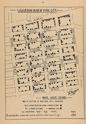
Robert Graham. “Liquordom in New York City: Where Whiskey Reigns, Chambers Street” and “Liquordom in New York City: Where Lager Reigns, Norfolk Street.” New York: Edward F. Weeks, 1883.
On loan from the Collection of PJ Mode.
These maps illustrate a pamphlet by Robert Graham, Secretary of the Church Temperance Society, an Episcopal organization founded in 1881. Graham concluded that it was uniquely difficult to control intemperance in New York, because the number of saloons there were “infinitely beyond the reasonable and legitimate requirements of the population.”
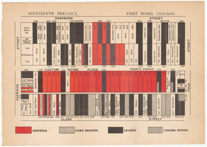
William Thomas Stead. “Nineteenth Precinct, First Ward, Chicago.” If Christ came to Chicago! A Plea for the Union of All Who Love in the Service of All Who Suffer. London: The Review of Reviews, 1894.
On loan from the Collection of PJ Mode.
This map uses color—in striking tones of red, black and grey--to convey a reformer’s view of vice in Chicago. He tallies the precinct’s 46 saloons, 37 “houses of ill-fame,” and 11 pawnbrokers.
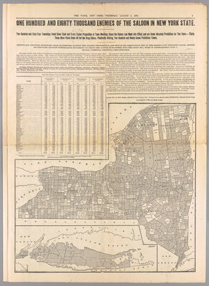
Bormay & Co. “One Hundred and Eighty Thousand Enemies of the Saloon in New York State.” The Voice, New York, August 5, 1897.
Gift of PJ Mode.
This map purports to show the support for Prohibition in New York State in 1897, but its message is diluted when one takes a closer look at the facts it presents. The 297 alleged “Prohibition Towns” amount to less than a third of New York’s 900 townships and the 26 counties that “Would be Absolutely Dry” amount to less than half of the state’s 60 counties.
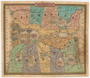
John Christian Wiltberger Jr. Temperance Map. Edward Yeager, engraver, 1838.
On loan from the Collection of P.J. Mode
This early allegorical temperance map reinforces its warning message by situating “The Land of Inebriation” at the bottom of the map (aligning it with the traditional location of Hell), while locating the “Land of Self Denial” Heavenward, at the top.
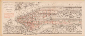
Henry William Blair. “Saloon Map of New York City.” The Temperance Movement or the Conflict between Man & Alcohol. Boston: William E. Smyth Co., 1888.
On loan from the Collection of PJ Mode.
William Henry Blair was a Republican senator from New Hampshire and an ardent supporter of prohibition. His description of this map states: “The eye is the chief inlet to knowledge, and the map of New York city which accompanies this book, upon which are located over 9,000 of the 10,168 saloons and places where intoxicating liquor was for sale in that metropolis on the thirtieth day of June, 1886, looks like a chart of the capital city of the regions of despair.”
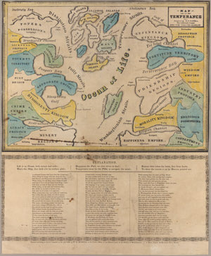
William Meacham Murrell. Map on Temperance. J. Howe, printer, and Ephraim W. Bouve, lithographer, 1846.
Gift of PJ Mode.
This early allegorical map on temperance is accompanied by a lengthy poem. Typical of didactic visual aids intended to be both instructive and entertaining, this colorful and intricate temperance map depicting the “Ocean of Life” offered viewers instruction on how to avoid temptations.