Additional Items
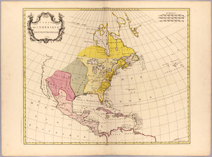
Jean Palairet. “Carte de l’Amerique Septentrionale 1754.” Atlas Methodique, 1754.
On loan from the Collection of PJ Mode.
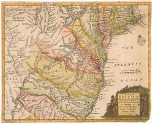
Emanuel Bowen. “A Map of the British American Plantations.” Thomas Bowen, engraver. The Gentleman’s Magazine, London, July 1754.
On loan from the Collection of PJ Mode.
In the years before and during the French and Indian War the British and French each claimed large, overlapping territories for their respective colonies on the continent, resulting in maps with conflicting messages. Palairet’s map conforms to the French view of North American colonization with the British lands narrowly contained along the east coast, while the entire area west of the Appalachians is “Nouvelle France” and “Louisiane.” The map of the “British American Plantations” makes it clear that the claims of the British colonies extend to essentially all of the land east of the Mississippi, with the borders of New England, New York, New Jersey and Pennsylvania extending essentially due north into modern Canada.
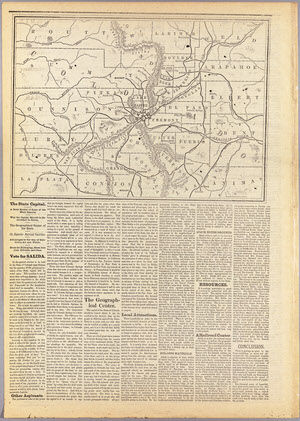
M. Moore. Salida – The State Capital. Rand, McNally & Co., 1881.
On loan from the Collection of PJ Mode.
When Colorado became a state in 1876, the drafters of its Constitution designated Denver the temporary capital and provided for selection of a permanent capital by popular vote five years later. J. M. Moore argued that Salida should become the state capital primarily because it was “the Geographical Center” of the state. Moore’s map distorted the sizes and shapes of several counties and cropped the northern and eastern sides of the map.
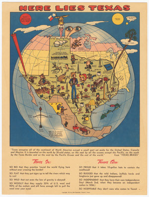
John Randolph. Here Lies Texas. Tomball, Texas, 1951.
Gift of PJ Mode.
A satirical map of Texas, with numerous illustrations and descriptions of the state’s “prettiest gals,” “best fishing,” “swiftest justice,” and “cryingest onions.”
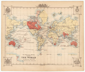
John Bartholomew. The British Empire Throughout the World on Mercators Projection, The British Possessions Coloured in Red. 1888.
Gift of PJ Mode.
A map that artificially increases the apparent size of the British Empire by presenting 420 degrees of longitude, so that portions of Australia are shown twice.
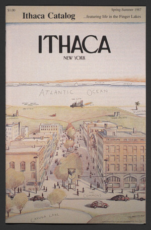
William Bensen. View of the World from the Ithaca Commons. Ithaca Catalog. 1987.
Gift of James Madden.
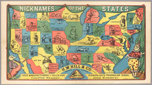
Mackowitz, engraver, and Trowbridge & Petford, designer. Nicknames of the States. H. W. Hill & Co.: Decatur, Illinois, 1884.
On loan from the Collection of PJ Mode.
This promotional map created by the H.W. Hill & Co., “a leading supplier to the nation’s livestock industry,” provides a porcine view of the country by presenting each state with a nickname and a hog illustration related to the nickname.
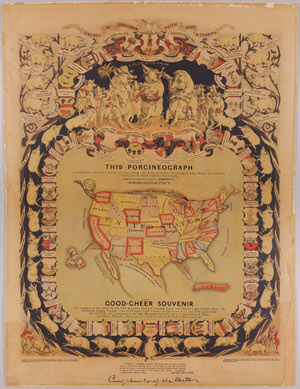
William Emerson Baker. This Porcineograph. Forbes Lithograph Manufacturing Co., 1876.
Gift of PJ Mode.
The “Porcineograph” is a humorous advertisement and souvenir map that presents the United States in the shape of a pig, combining “GEOHOGRAPHY” with the celebration and promotion of pork dishes from each state.
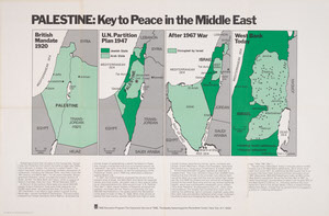
Paul J. Pugliese. Palestine: Key to Peace in the Middle East. TIME Education Program, TIME, the Weekly News Magazine, 1980.
Gift of PJ Mode.
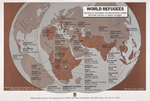
Paul J. Pugliese. World Refugees. TIME Education Program, 1979.
Gift of PJ Mode.
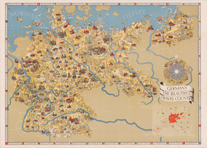
Walter Reimer. Germany, the Beautiful Travel Country. Reichsbahnzentrale fuer den Deutschen Reiseverkehr [German State Railway]. German Tourist Information Office, 1936.
Gift of PJ Mode.
This 1936 English-language map brochure promotes tourism travel to Germany—the Beautiful Travel Country—and shows scores of happy, prosperous, industrious Germans at work and play. The text on the back of the map provides all the details a tourist would need and then summarizes Germany’s recent political history and the rise of the national socialist movement and Nazi party.
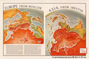
Robert M. Chapin. Europe from Moscow; Asia from Irkutsk. Reprint in enlarged format from Time Magazine, March 10, 1952.
Gift of PJ Mode.
This Cold War map shows the threat of the Soviet Union in Europe and Asia. The perspective of the map of Europe, and the progression of colors from dark to light, make it appear as if Soviet tanks could simply roll downhill into the heart of Western Europe and Asia.
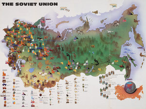
Novosti Press Agency. Soviet Union. 1983.
Gift of PJ Mode.
This large poster, another Cold War era map, promotes an appealing view of the Soviet Union as a place of tranquil natural beauty and burgeoning productive development.
Sydney E. Ayres and Mrs. Walter A. Henricks, compilers. Charles Maxwell Plaisted, illustrator. A Romance Map of the Finger Lakes Region. Penn Yan Print. Co., 1934.
Gift of PJ Mode.
This decorative promotional map of the Finger Lakes provides numerous historical vignettes and facts about the upstate New York region.
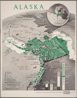
Robert M. Chapin. Alaska. Reprint in enlarged format from Time Magazine, June 9, 1958.
Gift of PJ Mode.
As Congress debated the issue of statehood for Alaska, this map was published by Time Magazine to present the argument for Alaska’s Cold War strategic significance.
Jain Cosmological Painting. Ca. 1900[?].
Gift of PJ Mode.
Adapting Buddhist and Hindu concepts into a cartographic expression, this Jain cosmological painting on cloth is an illustration of “Manusyaloka” – the World of Men.
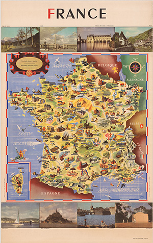
Cheval Batany. France [pictorial map]. Société Nationale des Chemins de Fer Français [French National Railway Company], 1947.
Gift of PJ Mode.
This French tourism poster, issued by the French National Railway, features a map filled with pictures that illustrate significant French historical, cultural, architectural, culinary, sporting, agricultural, industrial and religious sites.
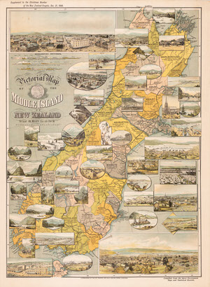
The New Zealand Graphic. Pictorial map of the Middle Island of New Zealand. N.Z. Graphic and Star Printing Works, 1898.
Gift of PJ Mode.
This early promotional map of the Middle Island of New Zealand offers birds-eye views of Christchurch and Dunedin. Its most remarkable feature is more than 40 inset views of towns, ports, natural landmarks and local activities such as mountaineering, coaching, farming, mining, and dredging.