Mapping the Metropolis
Even before Simeon De Witt and his Commissioners’ Plan of 1811 laid out Manhattan’s streets above 14th Street in their famous rectilinear grid pattern, New York City had been surveyed repeatedly. Throughout its history the metropolitan area has been the subject of maps that present countless social, political, and commercial perspectives on the city.
Maps providing political commentary include an 1884 perspective on the influence of Tammany Hall, a force in New York politics due largely to its willingness to help the city’s poor and immigrant populations. Tammany Hall leaders, like “Honest” John Kelley might not have been able to sway national elections, but they were “Still the Boss” in New York. These same immigrant populations were the subject of the state legislature’s Tenement House Committee report in 1895, which used a pair of “creative” maps to show the city’s population density and demographic makeup. While far from accurate, these maps could help persuade through their appearance of “scientific truth.”
Other maps portray New York’s cosmopolitan makeup. They promote its ethnic diversity, cultural treasures, and commercial ventures, which are presented as commodities ready to be explored and consumed.
Maps of New York appear throughout this exhibition. In “Concrete Socialism in Red,” we see its streets boldly colored to show that nearly half of the city’s surface—its roadways and parks as opposed to its privately owned real estate—is administered through public funding for the common benefit of all the people; while a “Saloon Map of New York” locates “over 9,000 of the 10,168 saloons and places where intoxicating liquor was for sale in that metropolis on the thirtieth day of June, 1886.”
With “A New Yorker's Idea of the United States” from 1936 and Saul Steinberg's famous 1976 New Yorker cover, "View of the World from Ninth Avenue,” we see the “truthiness” and humor of New York’s self-appointed position as the center of the world.
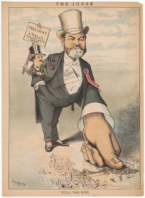
Grant Hamilton. “Still the Boss.” Judge, 1884.
Gift of PJ Mode.
This cartoon satirizes the power and influence wielded by Tammany Hall boss, “Honest” John Kelly, in New York City politics.
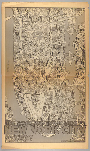
Bruce Carlton. “The Screw Convention Guide to New York City Sex.” Screw Magazine, 1980.
Gift of PJ Mode.
In August 1980, the Democratic Party Convention convened in New York City. Al Goldstein’s Screw Magazine welcomed the delegates with this satirical “Convention Guide to New York City Sex.”
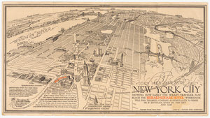
Richard Edes Harrison. An Aerial View of New York City Showing How Easily the Weary Traveler May Reach the Herald Square Hotel Wherein He Will Find the Rest, Comfort & Hospitality to Which He is Entitled, Even in This Day and Age. [1931].
Gift of PJ Mode.
This promotional map for the Herald Square Hotel shows an unusual bird’s-eye view of the city from midtown with attractive architectural renderings of newly-completed landmarks like the Empire State and Chrysler Buildings.
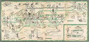
Henry E. Salloch. Cartoon Map of New York City. New York: J.J. Augustin, 1938.
On loan from the Collection of PJ Mode.
Henry Salloch, a German artist who fled to the U.S. in 1937, celebrated his new home as the capital of cultural pluralism with this tourist map that depicts New York’s neighborhoods as amusing, easily navigable places where historic sites and ethnic cultures could be enjoyed.
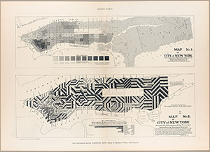
Frederick E. Pierce. “No. 1. Map of City of New York showing Densities of Population in the several Sanitary Districts, June 1, 1894 and No. 2. Map of City of New York showing the Distribution of Principal Nationalities by Sanitary Districts. Made under the Direction of The Tenement House Committee of 1894.” Harpers Weekly, January 19, 1895.
Gift of PJ Mode.
In 1894, the New York State legislature created a Tenement House Committee to examine the overcrowded conditions in New York. Their report used maps with the look of scientific truth—as opposed to clarity and accuracy—to convey information about population density and nationalities.
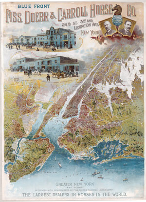
Fiss, Doerr & Carroll Horse Co. Blue Front Fiss, Doerr & Carroll Horse Co. Julius Bien & Co., lithographers, 1897.
On loan from the Collection of PJ Mode.
This late-19th century map-poster of New York was created as a promotion for the Fiss, Doerr & Carroll Horse Company, the “largest dealers in horses in the world.”
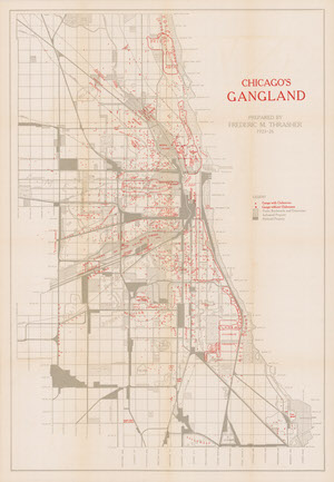
Frederic M. Thrasher. “Chicago’s Gangland.” The Gang: A Study of 1,313 Gangs in Chicago. Chicago: University of Chicago Press, 1927.
Gift of PJ Mode.
This map illustrates the findings from Frederick Thrasher’s 1927 study showing the location and distribution of 1,313 gangs in Chicago.
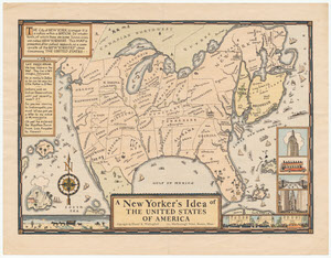
Daniel K. Wallingford. New Yorker’s Idea of the United States of America. Columbia University Press, 1936.
On loan from the Collection of PJ Mode.
This humorous pictorial map of the United States takes the perspective of a New Yorker, with New York shown in oversized proportion to the entire country.
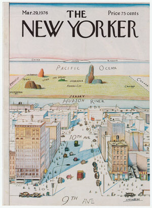
Saul Steinberg. “View of the World from Ninth Avenue.” The New Yorker. March 29, 1976.
Gift of PJ Mode.