Red and Blue America
Many persuasive maps show that partisanship and polarization across the spectrum of American political opinion are not new. Some of the cultural and political debates that still provoke opposing viewpoints today—such as the manipulation of electoral mapping—have long histories.
The satirical map, “The Gerry-Mander, or Essex South District Formed into a Monster!” is the origin of the now infamous word “gerrymander.” In 1811, the Massachusetts legislature redrew the state’s electoral boundaries in an effort to benefit the Jeffersonian-Republican party of Governor Elbridge Gerry. This legislation placed the long dominant Federalist voters into Senate districts where they would remain a minority, and concentrated the Jeffersonian-Republicans in districts where they could gain majorities. At a dinner party of prominent Bostonians, a Federalist examining the map of the redrawn Essex South District observed that its contorted shape resembled that of a salamander. Mocking the governor, another added that the district ought to be called a “Gerry-mander.” For Gerry, a signer of the Declaration of Independence and Vice President under James Madison, the attack was both political and personal. The mapmaker, Elkanah Tisdale, embedded a caricature of Gerry’s profile in the lower portion of the map—a hooked nose at Middleton and a jutting chin at Lynnfield—that now forever associates Gerry’s name with political manipulation.
When Henry Gannett, the superintendent of the United States Census, issued his red and blue map of the popular vote in the 1880 U.S. Presidential election, it was one of the first to feature electoral returns at the local level. Although it is election results at the state level that determine the outcomes of Presidential races, Gannett relegated the state electoral map to an inset and featured instead a larger map showing county-level returns. In the state map, the country appears divided along a north-south axis, but the county map uses an innovative scale of color shading to offer an analysis of regional party strengths, revealing a more nuanced political landscape that challenged conventional political wisdom about party dominance. It is also interesting to note that, while current conventions represent Democrats with the color blue and Republicans with red, the colors are reversed in this 1880 map.
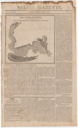
Elkanah Tisdale. “The Gerry-Mander Map.” Salem Gazette, Friday, April 2, 1813, 1813.
Gift of PJ Mode.
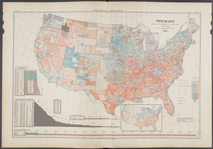
Fletcher W. Hewes. “Popular Vote: Ratio of Predominant to Total Vote by Counties, 1880.” Scribner’s Statistical Atlas of the United States. New York: Scribner, 1883.
Division of Rare and Manuscript Collections, Rare Books arZ120 +++
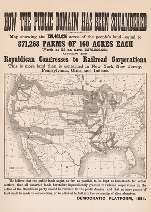
How the Public Domain Has Been Squandered. Chicago: Rand McNally and Company, 1884.
On loan from the Collection of PJ Mode.
This campaign poster from the 1884 Presidential election between the Democratic candidate, Grover Cleveland, and the Republican, Senator James G. Blaine, purports to show the area of “excessive” land grants given to railroads. Later research has revealed that the shaded area of the land grants shown covers about four times the number of acres stated in the accompanying text and that the map was massively deceptive in its presentation of data.
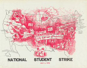
National Student Strike. 1970.
On loan from the Collection of PJ Mode.
In the Spring of 1970, civil unrest and protests against the war in Vietnam had spread across the U.S., and were particularly prevalent on college campuses. This poster protesting the War in Vietnam encourages a National Student Strike on May 6, 1970, listing the names of more than 100 colleges—including Cornell—already committed to the strike.
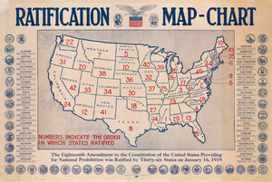
Lincoln-Lee Legion. Ratification Map-Chart. American Issue Publishing Co., 1919.
Gift of PJ Mode.
Published by the Lincoln-Lee Legion, a temperance organization founded in 1903, this poster celebrates the ratification of the 18th Amendment to the U.S. Constitution, enacting Prohibition as the law of the land. The large red numbers indicate the order in which the States ratified the amendment from the first, Mississippi, to the 45th, Pennsylvania.