Persuasion vs. Propaganda
The word “propaganda” – derived from the Latin term for the Catholic Church’s efforts to “propagate” the faith – has become a pejorative. In wartime, for example, American efforts to persuade are now “communication,” while the enemy’s are “propaganda.” By whatever name, persuasive cartography can influence political causes or points of view, sometimes in a biased or misleading way.
Examples here show how maps could be used as powerful weapons, particularly but not only in wartime. While they can unite a people behind a common cause by bolstering patriotism and morale during times of strife, messaging in this context can also rely on fear mongering, including racist or stereotyped representations of people or cultures to dehumanize an enemy.
In 1937, Howard Burke, an artist for the Los Angeles Examiner, published an eerily prescient map of a theoretical Japanese attack on the United States, pointing to the strategic significance of Pearl Harbor. Japanese planes and ships cover the Pacific Ocean, and insets show a predicted future bombing of Los Angeles and San Francisco.
A few weeks after the 1941 Japanese attack on Pearl Harbor, the Philadelphia Inquirer offered readers a “War Atlas” that reflected and supported the mood of the country. A brawny Uncle Sam, sleeves rolled up, represents a nation fully committed to the war effort: factories at work, soldiers training, planes and ships in motion.
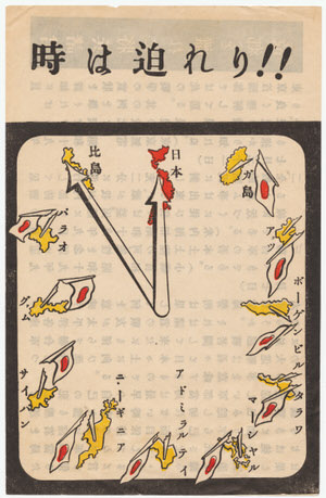
6th Army, Psychological Warfare Branch. The Hour is Drawing Near! 1945.
Gift of PJ Mode.
This propaganda leaflet was distributed to Japanese soldiers by allied forces. Each hour on the clock is marked by an island that had been liberated from Japanese control. The numbers 8-9-10-11 represent Saipan, Guam, Palua, and the Philippines, and 12 o’clock Japan.
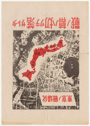
Tokyo Becoming a Battlefield – The War Has Begun. 1945.
Gift of PJ Mode.
This leaflet was dropped over Japan, probably at the time of the first intensive firebombing of Tokyo on March 9, 1945. All of Japan is shown in red, along with the text, which reads, “Tokyo Becoming a Battlefield - The War Has Begun.” The text on the verso is headed, “U.S. Air Force Intensively Bombs Tokyo.”
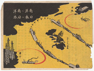
6th Army, Psychological Warfare Branch. War Supplies. 1944.
Gift of PJ Mode.
Produced by the Allied forces for distribution to Japanese soldiers in an attempt to persuade them to stop fighting, this map depicts a solid ring of aircraft carriers, submarines and other ships keeping oil and other vital supplies from reaching Japanese munitions industries.
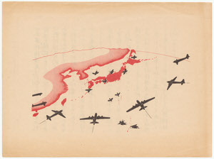
Office of War Information. Two Sparrows Cannot Drive Off Twenty American Eagles. 1945.
Gift of PJ Mode.
This leaflet illustrates how American scholars were trying to use Japanese philosophy and terminology as a weapon. The Japanese called their pilots, “Wild Eagles.” The map shows American B-29 bombers approaching Japan and small sparrows fluttering to earth. Text on the back read: “Two sparrows can’t drive off twenty American eagles.”
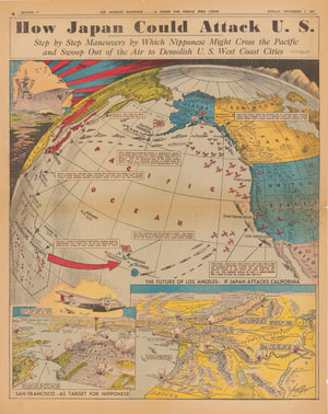
Howard A. Burke. “How Japan Could Attack U.S.: Step by Step Maneuvers by Which Nipponese Might Cross the Pacific and Swoop Out of the Air to Demolish U.S. West Coast Cities.” Los Angeles Examiner, November 7, 1937.
Gift of PJ Mode.
Howard Burke, an artist for the Los Angeles Examiner, created an eerily prescient 1937 map of a Japanese attack on the U.S. four years before it happened, highlighting the significance of Pearl Harbor. Japanese planes and ships cover the Pacific, and insets show the bombing of Los Angeles and San Francisco.
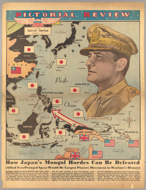
How Japan’s Mongol Hordes Can Be Defeated.” New York Journal American, Pictorial Review, December 5, 1943.
Gift of PJ Mode.
A heroic portrait of General MacArthur, larger than most of South Asia, dominates in this morale-building, full-page Sunday newspaper supplement map in color, showing how Japan will be defeated by ”the Largest Pincers Movement in Warfare’s History.“
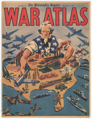
“War Atlas” and “Targets in Japan for U.S. Bombers.” Philadelphia Inquirer, February 13, 1942.
Gift of PJ Mode.
Published by the Philadelphia Inquirer just weeks after the attack on Pearl Harbor, this War Atlas reflected the mood of the country. A brawny Uncle Sam, sleeves rolled up, represents a nation fully committed to the war effort: factories at work, soldiers training, planes and ships on the move.