Introduction
Latitude: Persuasive Cartography features highlights from the PJ Mode Collection of Persuasive Cartography—maps intended primarily to influence opinions and beliefs, rather than to communicate geographical information. These “persuasive” maps are focused on shaping decisions and desired outcomes. They employ a variety of tools and strategies—unusual projections and coloring, selective inclusion, imaginative illustration, allegory, satire, and even intentional deception—to advance a particular cause or point of view.
Spanning from the 17th century to the present, many of the maps on display illuminate historical perspectives on topics that still resonate today, such as immigration policy and political gerrymandering. Others seek to foster social change, promote products and places, or send warnings about imagined futures. From the past to the present, Latitude helps us understand how ideas and opinions are shaped by data visualization techniques.
About the Collector
PJ Mode, Cornell Class of 1960, served in the U.S. Navy, graduated from Harvard Law School and worked for Robert F. Kennedy's 1968 presidential campaign. From 1970 to 1973 he was chief counsel of the U.S. Senate Subcommittee on Constitutional Amendments and chief legislative assistant to U.S. Senator Birch Bayh of Indiana. He was a partner and later chairman of the Washington, D.C., law firm Wilmer, Cutler & Pickering. From 2003 until retiring in 2013 he served as special counsel to Citigroup, managing the company's defense and resolution of investigations and lawsuits related to financial failures and credit crisis. A student and collector of maps since 1980, he now focuses on collecting, researching and writing about “persuasive cartography.” The maps on view in this exhibition represent only a fraction of his collection of over a thousand maps.
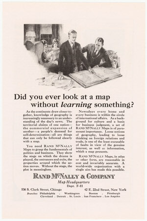
Rand McNally & Co. “Did You Ever Look at a Map Without Learning Something?” National Geographic, 1924.
Gift of PJ Mode.
The power of maps as a means of persuasion derives from the presumption that they are true and error-free. This advertisement from the map and atlas publisher, Rand McNally, emphasizes the point: “As a background for culture and a basis for business judgment, a set of Rand McNally Maps is of paramount importance…and invariably accurate.”
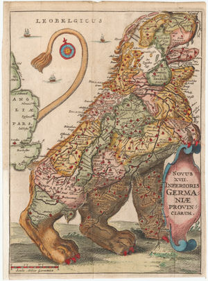
Leo Belgicus. In: Famiano Stada, De Bello Belgico, 1648.
Gift of PJ Mode.
The Leo Belgicus, used in both heraldry and map design, portrayed the former Low Countries (current day Netherlands, Belgium, Luxembourg, and northern France) as a lion. First drawn by the Austrian cartographer, Michaël Eytzinger, in 1583 during the Dutch War of Independence, it came to symbolize power, independence, and a common national identity.

Sea of Matrimony Pocket Map. J.I. Austen Co., 1906.
Gift of PJ Mode.
A map of matrimony uses an ocean voyage motif as allegory for charting the course of a happy marriage.
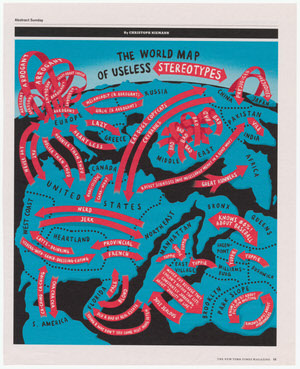
Christopher Neimann. “The World Map of Useless Stereotypes.” New York Times Magazine, July 10, 2011.
Gift of PJ Mode.
This satirical map of the world presents the “useless stereotypes” of our time. Interesting are instances where more than one country holds the same stereotypical view of others: each European country thinks the others are “Arrogant,” for example, and each Middle Eastern country considers the other “Bad.” Not surprisingly, given the source of the map, a disproportionately large New York metropolitan area fills roughly one-third of the map, with Bushwick regarding Greenpoint as “Yuppie,” Greenpoint considering Williamsburg the same, and so on into Manhattan’s East Village.
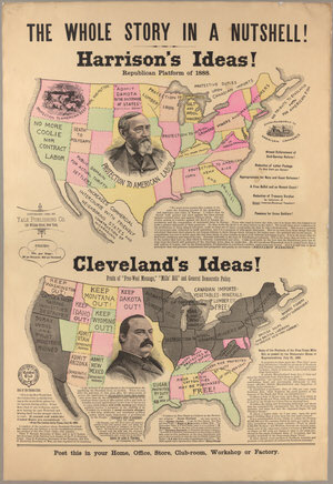
Yale Publishing Co. The Whole Story in a Nutshell! 1888.
On loan from the Collection of PJ Mode.
This political broadside offers partisan commentary on one of the central issues of the 1888 U.S. presidential campaign—trade policy. Distributed by the campaign for the Republican candidate, Benjamin Harrison (who supported high tariffs), the map predicts the dismal outcomes that would result should the Democratic candidate, Grover Cleveland (who attacked high tariffs as a burden on consumers), win the election. Although Cleveland narrowly won the popular vote, he lost the election because he failed to carry his home state of New York, causing him to lose the electoral vote to Harrison.
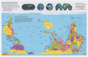
ODT, Inc. Hobo-Dyer Equal Area Projection. 2007.
On loan from the Collection of PJ Mode.
This map confounds customary cartographic expectations with its orientation, placing the Southern hemisphere at the top. The immediate effect is to enhance the significance of the countries south of the equator.
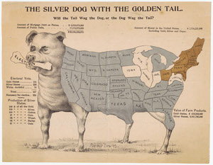
The Silver Dog with the Golden Tail. Pueblo Lith. Co., 1896.
On loan from the Collection of PJ Mode.
This flyer superimposes an outline map of the states on a fierce dog with an “Election” bone in its mouth. It supports the position of the populist Democratic candidate, William Jennings Bryan, on the critical issue in the 1896 Presidential race, “Free Silver.” The Republican candidate, William McKinley, opposed Free Silver for precisely the reason Bryan supported it, arguing that a dollar would be worth just 47 cents and economic chaos would ensue. In the end, McKinley won and the United States remained on the gold standard until the 1970s.
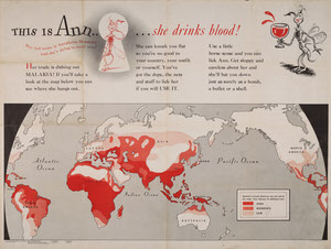
Theodore Geisel [Dr. Seuss]. This is Ann…She drinks blood! 1943.
Gift of PJ Mode.
This WWII U.S. Army poster was produced to educate troops about areas of malaria risk. It’s notable for its illustrations of the malaria mosquito, drawn by a young Army Captain named Theodore Geisel, better known today as the author and illustrator, Dr. Seuss. The text was likely written by Munro Leaf, author of The Story of Ferdinand.
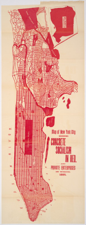
Walter Vrooman. “NYC Showing Concrete Socialism in Red.” Government Ownership in Production and Distribution. Being an account of 337 now existing National and Municipal Undertakings in the 100 Principal Countries of the World. Baltimore: Patriotic Literature Publishing Co., 1895.
Gift of PJ Mode.
With his bold use of color, Walter Vrooman, a socialist reformer, shows the simplicity of New York City’s political geography: buildings are privately owned, but the city’s streets and parks—nearly half of its surface area—are common ground administered by the public for the use and benefit of everyone.